
Siti UNESCO: Caserta, San Leucio verso Carditello
The research focuses on modeling historical ontologies to represent the social, architectural, and geographical context of the Bourbon sites, with particular attention to the hierarchical structure of the society of the time, combined with innovative approaches to semantic annotation and digital storytelling.
Domain Ontologies for Royal Bourbon Sites
The research team has developed “HistoricO,” a comprehensive historical ontology designed to represent the social, architectural, and geographical context of the Bourbon sites in a structured and interoperable way. This ontology enables precise modeling of social hierarchies, roles, events, and key locations, supporting the digital enhancement of cultural heritage through a systematic approach to historical knowledge representation.
The methodology for constructing the ontology included several rigorous phases:
- Specification of ontology requirements: Domain experts, primarily historians, specified the motivations for the ontology, defining potential scenarios, users, and applications that would benefit from such a structured representation. The ontology was designed to accurately model interactions between people, events, and contexts over time, supporting clear reconstruction of historical dynamics and relationships.
- Formal design: This phase involved term elicitation through competency questions addressed to domain experts, identification of ontology modules, and formalization of concepts using Description Logics notation. Terms were clustered to identify modules that would compose the ontology, resulting in a structured set of classes corresponding to ontological modules.
- Ontology construction: Knowledge engineers codified the identified modules using Protegè as the ontological editor and OWL (Web Ontology Language) as the standard language. After defining the modules, properties were established and the ontology was populated with individuals by historians. Consistency checks were performed through reasoning activities to avoid contradictions.
- Ontology evaluation: The evaluation focused on both competency and quality requirements. Gruninger and Fox’s criteria were applied to verify whether the ontology could answer specific questions and usage scenarios relevant to the modeled domain. Quality was assessed according to Gruber’s requirements: clarity (verified by historians to ensure terms were understandable without misunderstandings), coherence (tested using automatic reasoning tools), and modularity (ensuring the ontology could be divided into independent, reusable components).
Knowledge graph showing relationships between historical figures
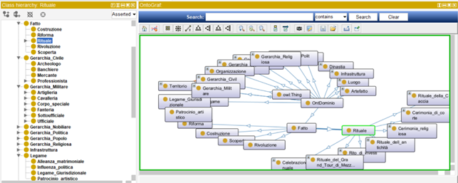
The ontology includes detailed hierarchies organized into several key categories:
- People and Social Hierarchy: A detailed representation of pre-modern social hierarchy, including noble titles (Sovereign, Baron, Baroness, Count, Countess, Duke, Duchess), clergy positions (Abbot, Friar, Pope), military ranks (Captain, Colonel, Corporal, Standard-Bearer, Infantry, Cavalry), and other professions (Composer, Builder, Diplomat, Official).
- Structures and Buildings: A comprehensive categorization of various types of structures, including public and commercial structures (Library, Shop, Café, Government Building), religious buildings (Cathedral, Dome, Religious Building), residential buildings (Dwelling, House, Farmhouse), and other structures (Aqueduct, Court, Public Structure).
- Geographical Locations: Concepts modeling both natural features (River, Hill, Continent) and man-made locations (City, Public Place, Recreational Place), providing geographical context for historical events.
- Events and Rituals: A hierarchy of various historical events, rituals, and celebrations important in historical societies, including ceremonies (Court Ceremony, Inauguration Ceremony, Investiture Ceremony, Religious Ceremony), celebrations (Carnival, Patronal Festival, Annual Celebration), and rituals (Hunting Ritual, Southern Grand Tour Ritual).
Property assertions for historical figure Giuseppe II Asburgo Lorena
Metadating and Semantic Annotation of Archival Content
The project has implemented sophisticated approaches to metadating and semantic annotation of digital contents related to the Bourbon sites, ensuring interoperability with national and international standards. This approach enables efficient organization, access, and reuse of digital cultural heritage through standardized descriptive frameworks.
The archiving system manages both digital versions of assets (photos, videos, 3D reconstructions, multimedia documents) and their descriptions. These descriptions contain information regarding the digital version (image format, compression format, tools used), archival context (position of the original asset, author, archiving process), and the asset itself.
A key innovation is the development of a technique that allows interoperability between various national and international metadata standards (ICAR, ICCU, LOD-LAM, Europeana). The team defined a language that creates a meta-level of metadata, capable of associating abstract and univocal concepts to elements present in various metadata standards. This semantic technology-based approach makes interoperability between metadata standards possible, allowing the digital content of the RASTA platform to connect transparently with major national and international archival systems.
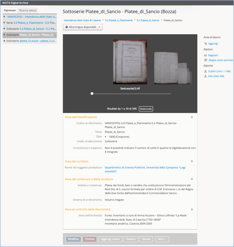
RASTA Digital Archive interface showing cataloguing of historical documents
The digital content regarding the royal Bourbon sites was metadated based on appropriately defined catalog cards, populating the RASTA archive. This content was then semantically annotated using the project ontologies, enabling subsequent population of semantic information and metadata relating to digital documents within the Archiving system. The documents are shared via Semantic Wrapping, ensuring broad accessibility while maintaining semantic richness.
Digital Storytelling Techniques and Applications
Through the analysis of various documentary sources—including court chronicles, administrative reports, diplomatic letters, and platee (detailed inventories of goods and properties)—the team reconstructed ceremonial dynamics and significant events of court life. The platee provided valuable information on spatial layouts, distribution of goods, and internal hierarchies, offering insights into the context of official celebrations.
From cross-referencing these data with other historical sources, coherent narratives emerged highlighting the main threads of Bourbon rituality:
The magnificence of power: Court ceremonies designed to exalt dynastic prestige and consolidate the sovereign’s role through rigid protocol, symbolic gestures, sumptuous clothing, and scenographic spaces.
Control of space and people: Audiences documenting room layouts and service personnel distribution, revealing well-structured hierarchies where each court member had a specific role during official events.
Interaction with subjects and nobility: Celebrations serving as occasions for public representation of power, where the Bourbon monarchy presented itself to the people and strengthened ties with the aristocracy.
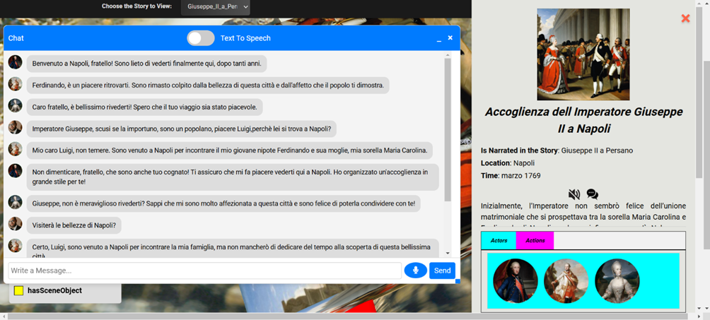
Digital storytelling interface showing historical event representation
The project developed innovative tools for digital storytelling:
- Story Composer: A tool for creating immersive and customizable narratives by importing domain ontologies and selecting actors, props, and locations necessary to create stories. The tool connects domain instances with structural elements of stories (plot, scenes, actions, events) and outputs JSON files that automatically populate the storytelling ontology.
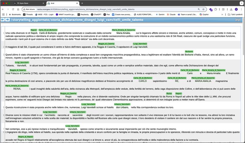
- Story Extractor: A more automated option for storytelling ontology creation that automatically populates the ontology directly from texts. The system recognizes entities in texts and associates them with domain instances defined in the ontology.
Storytelling ontology visualization showing story elements and relationships
Case Studies and Future Prospects
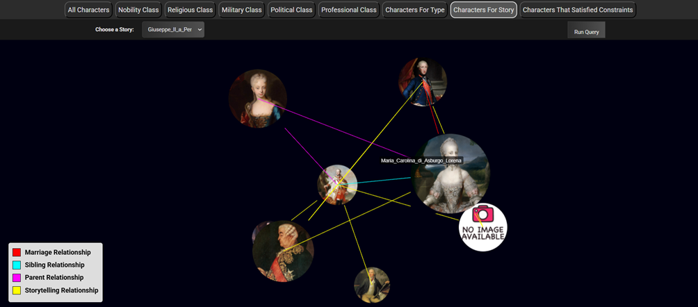
The case studies covered in this deliverable concern events and characters linked to the UNESCO sites of Caserta, San Leucio, and Carditello. For example, the story “Giuseppe II in Persano” was modeled with two plots, the first having “Giuseppe II puts his trust in Tanucci” as its first scene, associating actors (Joseph II of Habsburg, Maria Carolina of Habsburg, Bernardo Tanucci) and locations (Vienna) through semantic relationships.
This research provides an innovative approach to the valorization of historical heritage through digital technologies, offering new ways for visitors to experience and understand the cultural significance of these UNESCO sites. The integration of historical ontologies, semantic annotation, and digital storytelling creates a comprehensive framework for cultural heritage enhancement that can be applied to other historical sites and contexts.
Basilica di S. Angelo in Formis / Monte Pugliano/Norba
This case study aims to enhance and make more accessible three archaeological sites located in Lazio and Campania through the use of Augmented Reality (AR) applied to cultural heritage. The objective is twofold: on the one hand, to increase the availability of 3D models online following the best practices of important institutions such as the 3D Virtual Museum or the British Museum; on the other hand, to use AR technologies that can also be used by smartphones, making the immersive experience accessible to a wide audience. The multimedia and semantic content developed is being tested in pilot sites, while Unisalento supports Unicampania in evaluation activities. The digital assets created, along with the archive and knowledge base, represent a project legacy that extends beyond the life of the initiative.
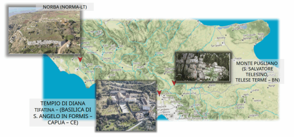
The project focuses on three sites:
Norba (Norma, Latina)
A Latin city founded in the 5th century B.C., Norba preserves imposing polygonal walls and an orthogonal urban layout, with domus from the Republican period, a bath complex and the sanctuary of Iuno. It is notable for its scenic location and exceptional state of preservation, having remained largely unchanged over time. The Norba Archaeological Park is accompanied by the Archaeological Museum “Father A. G. Saggi” in Norma, which integrates multimedia technologies to tell the story of the city and its inhabitants. The museum, housed in a historic building, has accessibility limitations, stimulating the creation of virtual experiences dedicated to visitors with mobility difficulties.
Monte Pugliano (San Salvatore Telesino, Benevento)
Situated between three towns, Monte Pugliano is home to a Samnite fortification, a Roman villa and a medieval settlement. The wall circuit, about 3.4 km long, follows the roughness of the terrain by exploiting natural defenses such as chasms and rocks. The wall is built with a dry polygonal technique, using large boulders, sometimes exceeding 2 meters. Digital reconstructions help to better understand the original structure. A main gate and three posterns have been identified, with features similar to those of Samnite fortifications. Investigations included field surveys, analysis of historical cartography and aerial photos.
Sant’Angelo in Formis (Capua, Caserta)
The present Benedictine basilica stands on the ruins of the Roman sanctuary of Diana Tifatina, a sacred place famous as early as Republican times. Documented by authors such as Pausanias, the temple enjoyed great prestige and was enriched by Sulla after one of his military victories. Remains of the podium and a floor mosaic are still visible in the basilica. Excavations have revealed two main building phases: the earliest in the 4th century BC, and a second in the late 2nd century BC, with the addition of new arches and ritual structures. There are remains of terraces and auxiliary buildings around the temple, also identified through aerial imagery. The hypothetical reconstruction of the building was worked out on the basis of comparisons with other monumental shrines, such as that of Hercules the Victor in Tivoli and Fortuna Primigenia in Palestrina.
Acquisition of digital content
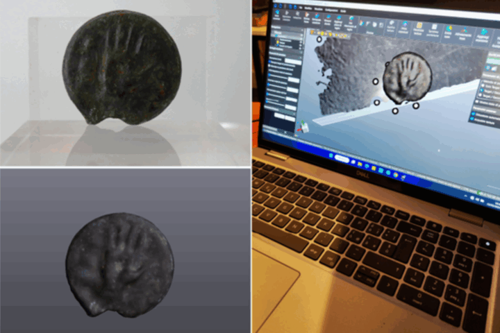
The technical activity began with the three-dimensional digitization of archaeological artifacts and environments. Depending on the complexity and characteristics of the artifacts, different technologies were adopted. Smaller and more detailed artifacts, such as Roman coins or bronze fragments, were acquired using high-precision structured light 3D scanners, ensuring high morphological fidelity. For larger and more articulated environments, such as the Norma museum’s oil cellar or the terraces of Monte Pugliano, mobile devices equipped with LiDAR sensors were used instead, capable of reconstructing interior environments and landscapes in an agile and rapid manner. The acquisitions were complemented by topographic terrain models, processed through GIS software, which allowed for a coherent three-dimensional representation of the archaeological and natural context of the sites.
Archiving and semantic structure of content
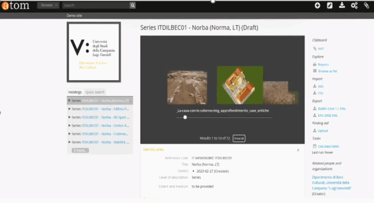
Once acquired, all digital content was organized into a structured, accessible and interoperable archive. The AtoM platform was used to manage and describe each item through the Encoded Archival Description (EAD) standard. Each archaeological site was treated as an archival fund, divided into thematic series that collect images, 3D models, videos, and historical texts. This archive, in addition to being searchable, was designed to dialogue with other platforms thanks to the conversion to IIIF manifest, which allows high-resolution display of content and easy integration with online viewers and annotation tools.
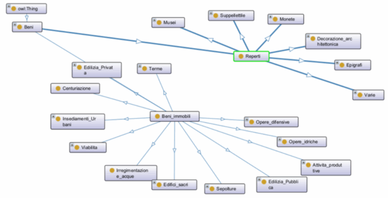
Ontologies and semantic annotation
One of the most innovative aspects has been the development of a dedicated ontology for archaeological heritage that can describe structures, artifacts, historical periods, and rituals in a formal and interoperable way. Particular attention was given to the numismatic domain, with ontological modeling allowing detailed representation of ancient coin features such as iconographies, inscriptions, and historical relationships. Semantic annotations were applied to both images and 3D models, leveraging IIIF-compatible tools such as Mirador, making it possible to navigate visually and conceptually through the digitized objects. In this way, the content is not only viewable, but also queryable and linked to structured knowledge.
Design of augmented cultural itineraries
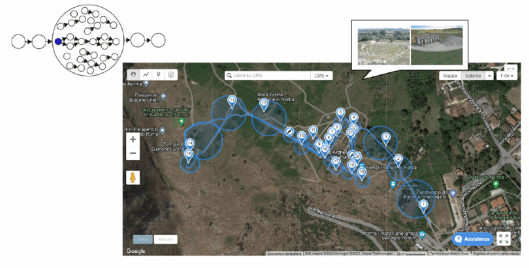
Starting with digital content and defined semantics, intelligent cultural itineraries were designed to guide visitors to discover the sites. Each itinerary was constructed as a sequence of points of interest, georeferenced and enriched with multimedia content, modeled to be accessible both on-site and remotely. The system was designed to adapt dynamically to the user’s profile and the content already enjoyed, creating a personalized experience consistent with individual interests. The design of the itineraries also took into account the physical criticality of the sites, offering virtual alternatives to visitors with mobility or sensory difficulties.
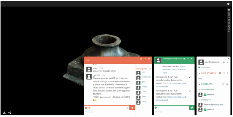
Automatic storytelling and intelligent interaction
To make the visitor experience more engaging, an adaptive storytelling system was implemented, capable of building dynamic narratives based on user interactions. Each point of interest serves as a “pearl” in a narrative that is built in real time, according to a logic defined as “string of pearls.” An intelligent conversational agent, based on Natural Language Understanding technologies and advanced language models, dialogues with the user, providing explanations, insights or suggestions. This system makes it possible to transform the visit from a passive sequence of content to a true interactive conversation, guided by the user’s curiosity and supported by 3D models or annotated images that react in real time.
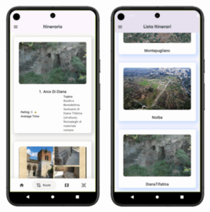
Mobile and augmented reality fruition
All developed content and features have been integrated into a mobile app made with Flutter technology, compatible with major operating systems. Through the app, users can explore selected itineraries, view 3D models in augmented reality, scan QR codes on the physical site to access contextual content, and receive voice or text information directly from their device. The interface is designed to be simple and accessible, with a focus on usability and adaptability to the archaeological context. The app also allows interaction with the virtual assistant, which guides visitors along the path and assists them in real time. As a further extension of the experience, advanced augmented reality devices such as Epson Moverio smart-glasses were also tested. These glasses allow 3D models and textual content to be overlaid directly in the user’s field of view, providing an immersive experience without the need for a smartphone. The integration of digital content with the glasses’ sensors, such as cameras and inertial measurement units, allows for smooth interaction with the actual archaeological space, enhancing accessibility especially in contexts where the installation of fixed infrastructure is limited by historical or environmental constraints.
Vallo di Diano
This case study focuses on creating an enriching visitor experience in the pilot sites through a series of related activities. It will start with a crucial phase of documentary research, involving the University of Molise in reviewing historical and territorial material relevant to the project. Subsequently, the relevant information for the territory-oriented narrative will be selected and structured, considering visitors' preferences. This selection will be based on external expertise, helping to create meaningful narrative modules. Once the information is acquired, we will move towards the production of multimedia modules, which will include animated graphics, augmented reality and virtual reality to engage visitors in an exciting way. Delivery, user profiling and content management technologies will be integrated within the platform. This will allow to personalize the experience and collect data for future adaptations. Furthermore, accessibility will be guaranteed, with the integration of assistive technologies for visitors with sensory or motor disabilities. The platform will be designed to accommodate the different needs of visitors. Finally, the implementation will proceed on the territory, spreading the information through traditional tourist circuits and trying to leave a distinctive mark. The visitor's satisfaction represents the best promotion, contributing to a positive profile for future visitors. All this will be followed by experimentation and validation of the results to ensure the overall success of the project.
Itinerari turistici Parco Nazionale Abruzzo
The pilot case of the Abruzzo Parks is supported by letters of intent from the Abruzzo and Molise National Park, as well as the Gran Sasso and Monti della Laga National Park. The activities involved include the instantiation of the CMS+SMR and IoT integrating infrastructure in the pilot case, a feasibility study for the integration of the system for calculating tourist routes, as well as the experimental integration of the Travel Planner. The system developed in this context is based on data from various sensors, open data accessible to the scientific community and graph analysis technologies. In addition, the use of mechanisms based on game theory are explored to incentivize the use of certain strategic sites and resources, in order to improve the tourist and cultural experience of the territory. Software and sensors was installed and calibrated at points of interest for the detection of smartphones and meteorological data. These data actively contribute to the analysis of visitor flows in the parks, allowing for improved user profiling and personalized experiences. A demo video of the implemented dashboards for tourism in action is available in the following:
Using these dashboards the decision makers can monitor in real time the situation of the points of interest selected in this case study and take informed decisions based on the produced charts and visualizations. For instance, some of the POIs showed that tourism is present also when weather conditions are not ideal, or other POIs demonstrated interrelated visiting activities stimulating possible cohesion between the managers and public transport. Furthermore, the system include automatic management and categorization of points of interest and user profiling techniques based on user-generated content analysis and sentiment analysis.
A demo video of the POI Management System and Semantic metadata repository developed in this context is available below:
This video shows how a framework can speed up the process of managing the POIs in an advanced way, including semantic enrichment of the POI description and automated categorization based on the interaction with Large Language Models.
Another demo video is available below showing the tool developed for validating the accuracy of the PMS and SRM components:
This tool is used validate the developed approach, proposing a tool to the expert in the field to manually annotated the POI descriptions. The data obtained are used to compare the user-manually-annotated POIs with the ones annotated automatically with AI. The aim of the experiment is to understand how to refine the prompts used to work with the LLMs to simulate or to get closer to the user-based annotation. A subset of the used POIs in the experiments are related to this OR.
Itinerari turistici in Umbria
The aim of this case study is to integrate a recommendation system into the Umbria Region Tourism Portal. This system, developed as a technological outcome, takes into account user profiling and ensures data security. An experimental validation of the classification of Points of Interest (POI) of Umbria will be conducted, considering different configurations of Topic of Interest (TOI). The POIs will receive scores with respect to each TOI configuration, which will be experimentally validated by comparing them with a "ground truth". Based on the validation results, a specific tuning for the POIs of Umbria will be performed to determine the best configuration of some algorithmic parameters. The recommendation system will be accessible both through the Umbria Region Tourism Portal and through mobile devices. Furthermore, to improve the experience of personalized routes, the app will be enriched with augmented reality technology. The experimentation and validation of the technologies employed in the pilot project will be conducted through the collection and analysis of data on the use of the system by users, with the aim of understanding the effectiveness of the proposed solutions and supporting the development of the territory.
Itinerari turistici in Puglia
In this case study, advanced technologies will be applied to enhance the experience of the pilot sites. The 2D mapping of the sites will be carried out and a 3D mapping of the interior spaces and objects will be created. Semantic annotation techniques will then be used to personalize the narrative and the user experience, respecting security and privacy. The use of advanced augmented reality devices, such as Microsoft Hololens, will also be explored to enrich the representation of objects in the scene with light and sound overlays. Projectors will be used to create immersive virtual environments. Wearable sensors and low-cost smart tags will be integrated to enable gesture-driven interaction for both artists and the audience. These sensors will be adapted to the needs of the project and we will focus on the versatility of the solutions adopted. Finally, experimentation and collection of results will allow to evaluate the compliance with the KPIs and identify potential technical or social issues.